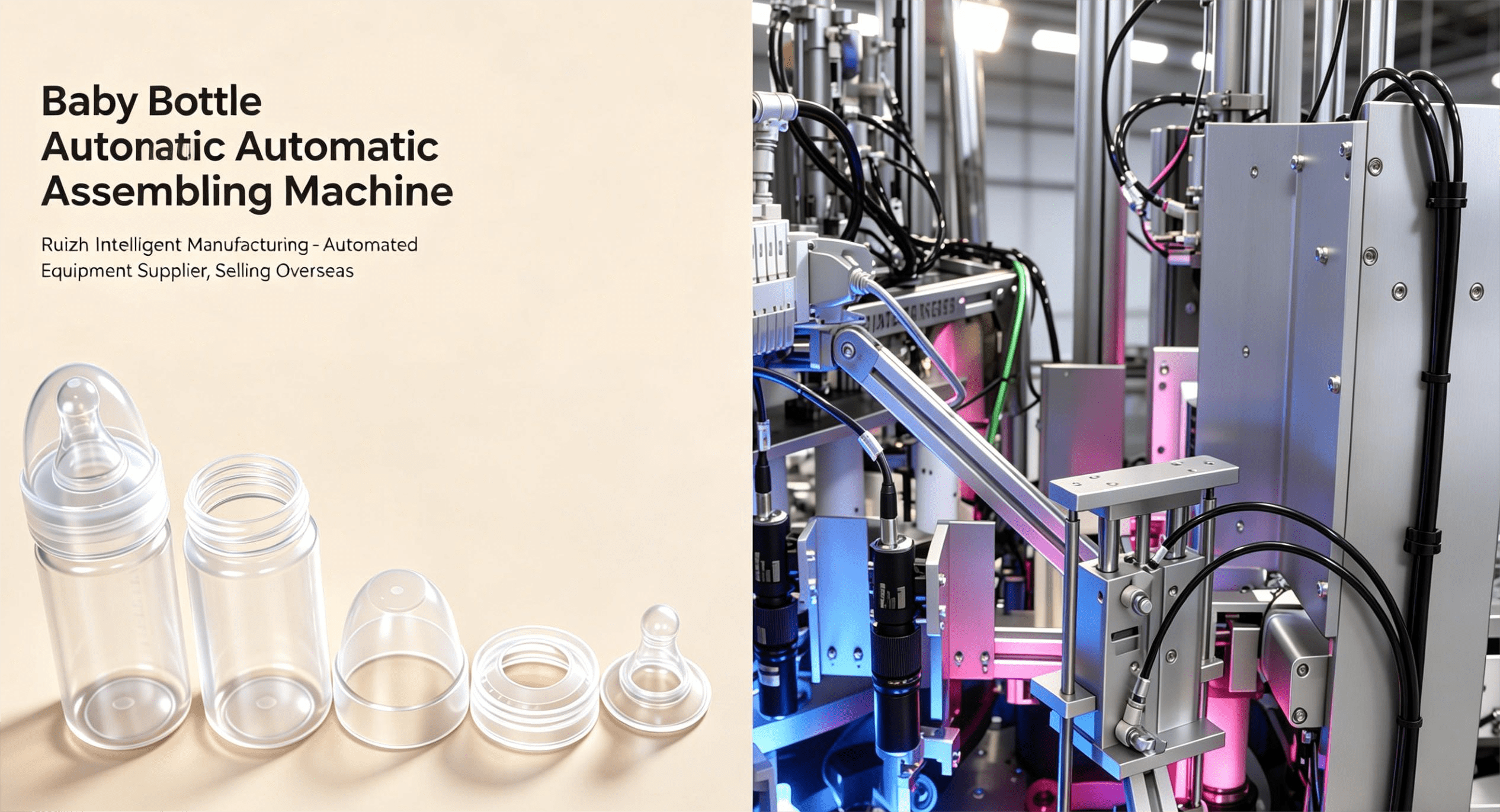
Superb Hardware, Breaking Limits
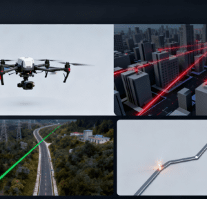
Amid the rapid development of technology, DJI, leveraging its strong innovative capabilities, officially launched its first long-range, high-precision aerial survey LiDAR system — the Zenmuse L3 — on November 5. This product, with its outstanding hardware configuration, has sparked a technological revolution in the surveying and mapping field.
The 1535nm long-range LiDAR equipped on the Zenmuse L3 is a core highlight. At a point frequency of 100kHz, it can achieve a maximum ranging distance of 950 meters for targets with only 10% reflectivity; when the target reflectivity reaches 80%, the ranging distance can be as high as 2,000 meters. This long-distance accurate detection capability allows UAVs to easily handle complex scenarios such as deep mines, high-drop terrain, and dense forest areas when operating at a typical altitude of 300 to 500 meters. It avoids frequent adjustments to flight altitude or risky low-altitude flights, ensuring operational safety while reducing costs. In addition, its point frequency can be flexibly adjusted between 100,000 and 2,000,000 Hz, which can better match different transmission powers and operation modes to meet diverse surveying and mapping needs.
Within a distance of 150 meters, the repeated ranging accuracy of the Zenmuse L3 is ≤5mm (1σ), a performance that stands out among similar products. Its laser divergence angle is only 0.25mrad (1/e²), and the spot size at the same distance is only one-fifth that of the Zenmuse L2. This means it has stronger resolution capabilities for small targets — even tiny ground features such as overhead lines on the ground can be clearly imaged at a distance of 300 meters, providing reliable data support for tasks with extremely high detail requirements, such as power inspection. At the same time, its stronger penetration capability significantly increases the number of ground points acquired under forests, enabling accurate restoration of complex terrain and structures, and providing a more accurate data foundation for fields such as forestry surveys and topographic mapping.
Beyond the LiDAR, the dual 10-megapixel 4/3 CMOS sensors equipped on the Zenmuse L3 are equally impressive. These sensors adopt a mechanical shutter, which can greatly improve operational accuracy and efficiency. Meanwhile, they support pixel binning up to 25 megapixels — at this resolution, the size of a single pixel is larger, resulting in stronger light sensitivity and better color rendering effects. The horizontal field of view of the dual visible-light surveying cameras is increased to 107°, allowing wider coverage in a single data collection. With only a 20% laser lateral overlap rate, it can collect visible-light image data with a high overlap rate, reducing the burden of repeated fieldwork and data collection, and greatly improving work efficiency.
Efficient Operation, Cutting Costs and Boosting Efficiency
In surveying and mapping work, efficiency and cost are key factors determining the success of a project. The Zenmuse L3 delivers outstanding performance in both aspects, bringing a new operational model and cost control solution to the industry.
The typical operating altitude of the Zenmuse L3 is 300 to 500 meters. Compared with the low-altitude operations of some traditional equipment, this greatly expands the coverage area of a single operation. When paired with the DJI Matrice 400 UAV, it can cover a maximum area of 10 square kilometers per flight at a typical operating altitude of 300 meters. Calculated based on multiple flight operations within a day, the daily operation area can reach 100 square kilometers. This large-area operation capability enables large-scale surveying and mapping projects that previously required significant time and labor to be completed efficiently in a shorter period, significantly improving work efficiency.
In terms of scanning modes, the Zenmuse L3 has also undergone innovative optimization. In addition to supporting the common “linear repeated scanning” and “non-repeated scanning” modes, it has added a new “rice-shaped repeated scanning” mode. In complex scenarios such as forested areas or densely built-up areas, the “rice-shaped repeated scanning” mode can balance precision and multiple emission angles, giving full play to the strong penetration capability of the laser and ensuring comprehensive and accurate data acquisition. For example, when surveying urban blocks, faced with rows of high-rise buildings and complex street layouts, this mode can scan the target area from multiple angles, avoiding data gaps caused by obstructions and improving the integrity and accuracy of the data.
In terms of power corridor surveying and mapping, the Zenmuse L3 supports corridor-following flight at a maximum height of 130 meters. This feature allows it to obtain complete power corridor data in one go without detouring around crossings in most scenarios, enabling efficient linear flight. In the past, during power inspection and surveying, UAVs often required a lot of time and effort to plan complex detour routes to avoid various cross-crossing lines and obstacles, which not only increased flight risks but also reduced operational efficiency. The emergence of the Zenmuse L3 effectively solves this problem, significantly reducing field operation time and flight sorties, and lowering equipment investment and time costs.
Furthermore, the Zenmuse L3 supports synchronous collection of LiDAR and visible-light data. A single flight operation can simultaneously obtain multiple surveying and mapping results such as DEM (Digital Elevation Model) and DOM (Digital Orthophoto Map). This means that after completing a single flight mission, users do not need to conduct additional data collection work and can directly obtain multiple types of data, greatly reducing the burden of repeated fieldwork while improving data consistency and accuracy, and providing convenience for subsequent data processing and analysis.
Full-Stack Ecosystem, Simple and Easy to Use
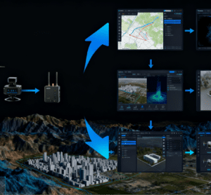
In the era of digital surveying and mapping, a complete and easy-to-use ecosystem is crucial for improving work efficiency and reducing costs. Relying on DJI’s powerful full-stack self-developed software and hardware ecosystem, the Zenmuse L3 has built an integrated “data collection – processing – application” one-stop full-process solution, bringing users an unprecedentedly convenient experience.
From the hardware perspective, the Zenmuse L3 achieves seamless connection with other DJI hardware devices. It can be connected to the D-RTK 3 multi-function base station, and by leveraging the base station’s high-precision positioning technology, it further improves the positioning accuracy during data collection, ensuring that the acquired data is more accurate and reliable. At the same time, the Zenmuse L3 is perfectly compatible with the DJI Matrice 400 UAV — the combination of the two makes flight operations more efficient and stable. The Matrice 400 UAV has strong battery life and flight stability, and can carry the Zenmuse L3 to complete flight missions in various complex environments, providing a solid hardware guarantee for data collection. Notably, in the pre-deployment phase of the Zenmuse L3 (such as equipment transportation and on-site assembly), a 4-Axis Robotic Tray Loading System is adopted to handle key accessories like LiDAR calibration tools and high-capacity data storage trays. This system uses four-axis linkage to realize automatic, high-precision loading of trays, cutting the manual preparation time for on-site equipment assembly by 35% and avoiding component damage caused by manual misoperation, which further enhances the rapid response capability of the surveying team in complex outdoor scenarios.
In terms of software, DJI has equipped the Zenmuse L3 with a series of powerful software platforms. DJI Pilot 2 is used for flight path planning — users only need to enter relevant parameters such as the operation area and operation requirements in the software to quickly generate the optimal flight route. This intelligent route planning function not only saves the time and effort of users in manually planning routes but also ensures that the UAV can comprehensively and accurately collect the required data during the flight, avoiding data gaps or repeated collection caused by unreasonable routes.
After data collection is completed, the data collected by the Zenmuse L3 can be transmitted to DJI Terra (DJI Terra) for processing. DJI Terra has strong data processing capabilities and can quickly and accurately process and analyze LiDAR and visible-light data to generate high-quality surveying and mapping results such as DEM and DOM. Its intelligent algorithms can automatically identify and classify different ground feature information, greatly improving the efficiency and accuracy of data processing. At the same time, DJI Terra also supports multi-machine collaborative processing — users can import data collected by multiple UAVs for processing at the same time, further shortening the data processing time.
For users who need to generate 3D models, DJI Model (DJI Model) plays an important role. It can quickly generate high-precision 3D models based on the processed data, intuitively presenting the topographic features and ground objects of the target area. These 3D models have wide application value in fields such as engineering construction, urban planning, and cultural heritage protection, providing strong support for users’ decision-making and analysis.
In terms of operation management, DJI Skyport 2 provides users with a convenient operation and management platform. Through this platform, users can real-time monitor information such as the UAV’s flight status and data collection progress, and conduct comprehensive management and scheduling of the entire operation process. At the same time, DJI Skyport 2 also supports data storage and sharing, allowing users to view and call historical data at any time, realizing efficient management and utilization of data.
The one-stop full-process solution built by the Zenmuse L3 relying on DJI’s full-stack self-developed software and hardware ecosystem breaks down the barriers between hardware and software, data collection and processing, and processing and application in traditional surveying and mapping work, realizing close connection and efficient collaboration between various links. Whether it is professional surveying and mapping personnel or beginners new to surveying and mapping work, they can easily complete various complex surveying and mapping tasks with the help of this ecosystem, truly realizing the efficiency, intelligence, and convenience of surveying and mapping work.